About 全国避難所ガイド
Disaster prevention information "National Evacuation Center Guide" Ver.6.1 [New features in Ver6.1] - Advice of "Chat GPT" is displayed in disaster prevention information. ・In conjunction with the announcement of civil
Disaster prevention information "National Evacuation Center Guide" Ver.6.1
[New features in Ver6.1]
- Advice of "Chat GPT" is displayed in disaster prevention information.
・In conjunction with the announcement of civil protection information, the civil protection evacuation facility will be displayed.
・During normal times, the display can be switched between disaster shelters/evacuation sites and civil protection evacuation facilities.
[New features in Ver6.0]
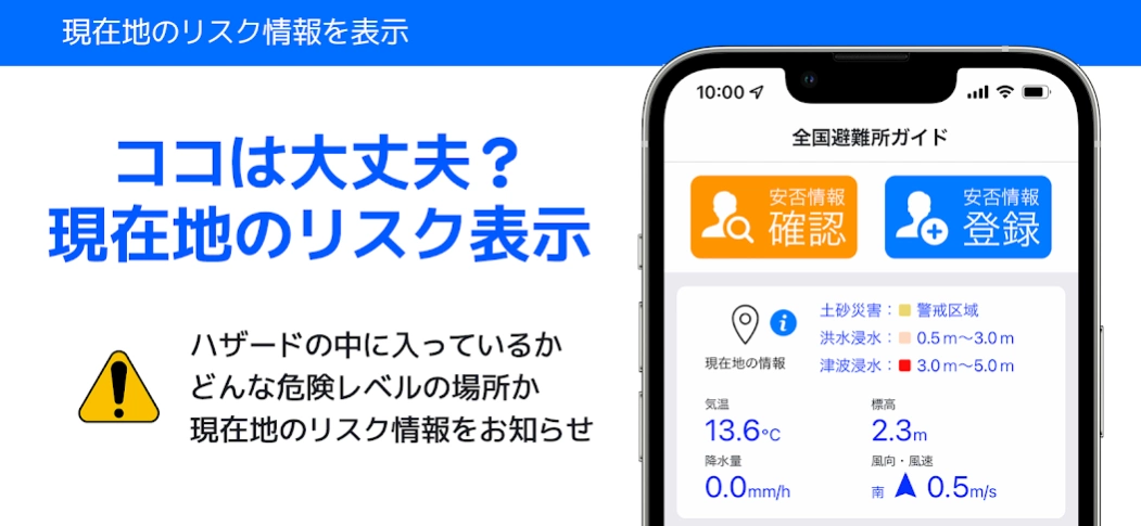
- Displays the disaster risk information of the current location on the top screen.
・Evacuation center congestion status can now be displayed.
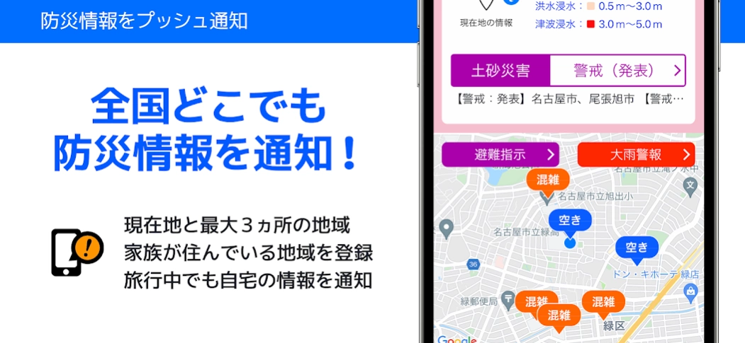
・Disaster prevention information will be notified by push notification of up to 3 locations other than the current location.
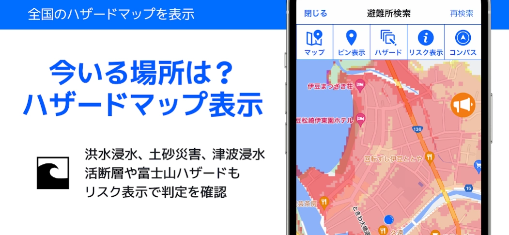
・Displays a hazard map of landslide warning areas, flood and tsunami inundation areas.
- The user interface has been greatly improved.
Disaster prevention information "National Evacuation Guide" is a disaster prevention information app for smartphones that automatically searches for evacuation centers and evacuation sites around your current location, displays various hazard maps, and notifies you of disaster prevention information for your current location by push notification.
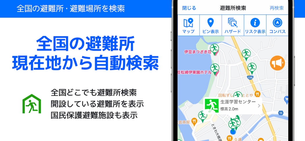
More than 150,000 evacuation sites and evacuation sites designated by local governments nationwide are recorded and updated daily.
Automatically search for shelters and evacuation sites around your current location, and provide route guidance to facilities and an evacuation compass to support evacuation actions in the event of a disaster.
By registering your current location and up to 3 areas, you will be notified of various disaster prevention information such as evacuation information and weather information by push notification.
By using the safety registration and safety confirmation functions, it is useful for evacuation drills in preparation for disasters and for confirming the safety of family members in the event of a disaster.
National Evacuation Center Guide Support Site
http://www.hinanjyo.jp/
[Recorded data]
・More than 150,000 cases in the national evacuation center database (database is updated from time to time)
・National evacuation centers (designated evacuation centers), evacuation sites (designated emergency evacuation sites), temporary accommodation facilities for people unable to return home, tsunami evacuation facilities, disaster medical institutions, water supply bases, etc.
[Disaster prevention information]
・Evacuation information, evacuation center information, evacuation center congestion status
・Weather note warning, landslide warning information, designated river flood information, earthquake information, tsunami information, eruption information, etc.
[Main functions]
● Disaster risk information for your current location
・The inside/outside judgment of the hazard map and the area division/inundation depth level are displayed.
・In normal times, temperature, precipitation, altitude, wind direction and wind speed are displayed.
・Evacuation information, weather warnings, landslide warnings, and river flooding warnings are displayed in the event of a disaster.
●Evacuation center automatic search
・When the app starts up, it will automatically search for shelters and evacuation sites around your current location.
・Display information on open shelters and shelter congestion status.
- Display the route guidance from the current location to the evacuation center.
・Cache shelters and maps are displayed even when you are offline.
● Hazard map display
・Displays a hazard map of landslide warning areas, flood and tsunami inundation areas.
●Risk display
・The latitude, longitude and altitude of the current location are displayed.
・Evacuation information issued for your current location and weather warnings will be displayed.
・The inside/outside judgment of the hazard map and the area division/inundation depth level are displayed.
● Evacuation compass / AR camera function
・Supports evacuation behavior by displaying the direction and straight-line distance to the shelter or home.
・ The direction of the shelter and home is displayed on the AR camera (augmented reality) screen.
・Even when you are offline, you can use the evacuation compass and AR camera functions.
●Safety registration/safety confirmation
・You can register your safety from your current location or evacuation center. (Registered in Google Person Finder)
・You can check safety information from Google Person Finder, Disaster Message Board (web171), J-anpi Safety Information Collective Search.
・ You can register your family group Gord and check the safety of your family.
●Area information
・Displays the link information of the Japan Meteorological Agency, the Ministry of Land, Infrastructure, Transport and Tourism, lifeline information, railway operation information, domestic flight operation information, and Twitter disaster prevention account.
・The local government website link of the current location is displayed.
●Disaster prevention information
・You will be notified by push notification of disaster prevention information for your current location and up to 3 locations.
・ You can push notification of disaster prevention administrative radio broadcast in the selected area and play audio.
* Reception of disaster prevention administrative radio broadcasting is limited to areas that support it.